

Bonvo.Ski
Immersive 3D Snowboard Maps & AR Navigation.
7 followers
Immersive 3D Snowboard Maps & AR Navigation.
7 followers
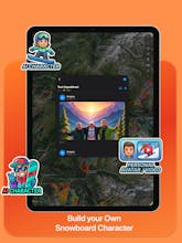
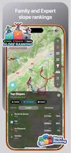
Ski resorts are 3D environments, yet most apps still use static 2D images. I built Bonvo.Ski to solve this. It renders mountain terrain in true 3D to help you visualize run difficulty and steepness before you drop in. Beyond mapping, it handles real-time friend tracking and AR wayfinding to identify lifts through your camera. The engine is optimized for offline use to save battery in the cold. I also just added a schedule tracker for the Winter Olympics.


Hey Product Hunt! 👋
Gergely here, maker of Bonvo.Ski.
I built this because I was frustrated with paper maps and static JPEGs. Mountains aren't 2D, so why should our maps be? I wanted a way to visualize the steepness of a run and find my friends without taking off my gloves to type a text.
Bonvo helps you:
Understand the terrain in 3D.
Locate friends instantly on the mountain.
Use AR to see exactly where that lift leads.
We are live on iOS today. I'd love to hear your feedback on the map rendering and what mountains you'd like to see next!
See you on the slopes! 🏂
I have 50 Monthly Pro codes for the Product Hunt community!
Since these are unique App Store codes, I can't list them all here. Just leave a comment below telling me your favorite ski resort (or one you want to visit), and I will DM you a free code!
First come, first served! 🚀