Fieldly helps field professionals capture GPS-tagged photos with customizable stamps and generate professional reports for inspections, construction, surveying, maintenance, and site documentation. Record every detail with accurate location, time, and metadata—all in one app.
No reviews yetBe the first to leave a review for Fieldly: GPS Camera, Timestamp
Maker
📌
Hi Product Hunt! 👋
We're excited to introduce Fieldly, a GPS camera built for professionals who need accurate, reliable photo documentation in the field.
Whether you're working in construction, engineering, surveying, inspections, utilities, or property management, Fieldly helps you capture every photo with the information that matters.
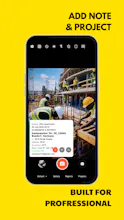
📸 Capture More Than Just a Photo
Every image can include customizable overlays such as:
GPS coordinates
Address
Date & time
Altitude
Compass direction
Speed
Weather
Custom notes
Project information
🗂 Built for Field Work
Create customizable photo stamp templates
Organize photos by project
Capture high-quality images
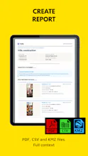
Export professional PDF reports
Share reports with clients or team members
Fast, clean, and easy-to-use interface
🌍 Perfect For
Construction progress
Site inspections
Land surveying
Property documentation
Facility maintenance
Insurance claims
Utility inspections
Travel documentation
Our goal is simple: make field documentation faster, more accurate, and more professional.
We're continuously improving Fieldly based on feedback from professionals who use it every day.
We'd love to hear:
Which metadata is most important in your workflow?
What reporting or field tools would you like to see next?
Thanks for checking out Fieldly! 🚀
Report
Love how the stamps sit cleanly on top of photos without obscuring key details, and the metadata stays editable before finalizing. The report export looks polished too.







Love how the stamps sit cleanly on top of photos without obscuring key details, and the metadata stays editable before finalizing. The report export looks polished too.